Introduction
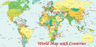
The World Map With Countries app is designed to help users understand the geographical boundaries and locations of important places around the world. It showcases continents, countries, transcontinental countries, independent and dependent territories, oceans, seas, islands, and more. The app also features the network of lines representing meridians and parallels, as well as the geographic coordinate system. With its political world map, users can easily grasp the administrative boundaries of all countries. This app is essential in understanding not just geographical, but also political divisions, which contribute to maintaining peace and enforcing laws worldwide. Download the World Map With Countries app now to explore the world in a simplified and visual way.
Features of this app:
- Geographical boundaries: The World Map With Countries app provides a clear representation of the geographical boundaries of all continents and countries. Users can easily understand the specific boundaries of each country.
- Important places: This app helps users to identify and understand the geographical location of important places around the world. It provides information about major cities, landmarks, and other significant locations.
- Transcontinental countries: The app also includes information about transcontinental countries, which are countries that span across multiple continents. Users can explore and learn about these unique countries and their geographical features.
- Oceans, seas, and islands: The World Map With Countries app displays the world's oceans, seas, large and small islands, and other bodies of water. Users can easily visualize and understand the distribution of these water features on the map.
- Meridians and parallels: The app includes a network of lines that represent meridians and parallels, which make up the geographic coordinate system. Users can learn about latitude and longitude and how they are used to locate specific points on the map.
- Political divisions: In addition to geographical boundaries, the app also depicts political divisions. Users can see the administrative boundaries of each country, helping them gain a better understanding of the political landscape of the world.
Conclusion:
With its user-friendly interface and informative features, the World Map With Countries app provides a simplified and visual way to explore and learn about the world. It allows users to understand geographical boundaries, locate important places, and gain insights into political divisions. Whether for educational purposes or general knowledge, this app is a valuable tool for anyone interested in understanding the world around them. Click here to download the app and start exploring today!
- No virus
- No advertising
- User protection
Information
- File size: 12.00 M
- Language: English
- Latest Version: 1.3
- Requirements: Android
- Votes: 73
- Package ID: com.maps.worldmapwithcountries
- Developer: APK Store
Screenshots
Explore More
Explore the world with confidence using our intuitive map software. Navigate unfamiliar cities, find hidden gems, and plan adventures with ease. Our powerful apps feature robust offline functionality, real-time traffic updates, and crowd-sourced points of interest. Customize maps to match your needs - save favorite locations, download areas for offline access, and share recommendations.

TravelBoast

GameKeyboard +

English Bhagavad Gita

Air Navigation Pro

Watch Duty (Wildfire)

RoadStr

Kansas State Fair

WHIO Weather
You May Also Like
Comment
-
I like2023-12-13 01:39:21
-
More2023-12-12 08:39:06
-
Excellent2023-12-11 19:06:07
-
The best2023-12-11 03:59:59
-
ুীডকহসজআ2023-12-09 18:11:31
-
Good2023-12-09 02:34:46


