Introduction
skateable is a compact utility designed to help skaters decide whether a local park or spot is worth the trip by delivering a live skateability score for each location. The app combines current weather, the last 48 hours of rain history, surface type, sun exposure and drainage quality into a single 0–100 score so you can skip guesswork and go straight to riding. Use the forecast tool to plan sessions up to seven days ahead, check community session reports from other skaters who log whether a park was dry or wet, and save the spots you ride most often to access them quickly.
Key features and what they mean in practice
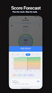
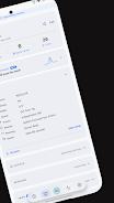
skateable calculates a live skateability score that blends objective weather data with subjective, recent rider reports so the score reflects both forecasted conditions and what skaters are actually finding on the ground. The Plan Session forecast breaks down predicted skateability for any hour in the next seven days, letting you compare morning, midday and evening windows. Detailed park profiles store attributes such as surface type (modern smooth, old concrete, rough asphalt, timber, steel, indoor), sun exposure and an estimated drainage rating to explain why a score looks the way it does.
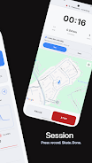
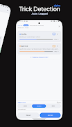
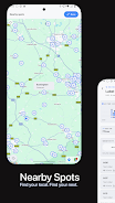
Community sessions are simple reports submitted by riders indicating whether a spot is dry, wet, or has a particular hazard that day. Those reports appear on park timelines and contribute to the live score, and you can flag inaccurate entries so data stays useful. Locations and map tools let you save parks to a personal list, search by name or filter by distance, and view spots on a map with a Nearby view that surfaces places close to you.
How interactions and controls work
Interacting with skateable is straightforward: tap a park to open its profile, swipe left or right along the forecast timeline to compare conditions across days and hours, and pinch or pan the map to find spots in different neighborhoods. The forecast tool is a tap-and-scroll interface that shows hourly skateability so you can pick a specific time to aim for. Reporting a session requires only a few taps to mark a park dry or wet and add an optional short note about hazards, which keeps logging fast when you arrive or leave a session.
Progression, personalization and long-term value
Even though skateable is a utility rather than a game, it supports a natural progression in how you use it: beginners can discover nearby smooth surfaces and avoid unsafe spots, while more experienced riders build a curated library of favorite parks with notes about best times and local hazards. Saved spots act like a personal itinerary: over time your list becomes a quick-referral resource for weekend plans and group sessions. Personalization options let you set preferred distance ranges and display filters so search results reflect the spots you actually ride.
Visual style, map layers and clarity
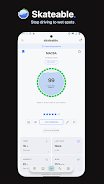
The app prioritizes clear map-based navigation and readable park profiles with concise icons and color-coded skateability scores. Map layers display basic context such as satellite imagery or a simplified street map, and park pages use consistent symbols for surface type, sun exposure and drainage so you can scan conditions at a glance. Condition cards are shareable with your crew and present the same clear information whether viewed in the app or sent as an image.
Accessibility, reliability and offline considerations
skateable aims to be accessible through a clean layout, scalable text and high-contrast elements that help visibility in bright outdoor light. Core reporting and viewing workflows require an internet connection to fetch the latest weather and community reports, but saved spots and recent condition cards remain available on-device so you can reference them when service is limited. The app also offers simple error messages and data flagging so you know when a score is based on sparse information.
Limitations and accuracy notes
While skateable helps reduce travel time and guessing, its accuracy depends on the quality of weather feeds and the volume of recent community reports for a given park. Forecasted skateability is a prediction and cannot guarantee a dry or hazard-free surface at the scheduled time, and park attributes are only as complete as the information contributors provide. Use the app as a decision aid to prioritize where and when to ride, and continue to check a spot in person when exact surface conditions are critical.
- No virus
- No advertising
- User protection
Information
- File size: 83.46 M
- Language: English
- Latest Version: 2.0.0
- Requirements: Android
- Votes: 281
- Package ID: com.paulmwhite.skateable
- Developer: Paul M White
Screenshots


Explore More
Be prepared and plan your days better with our new weather app. Get real-time hyperlocal forecasts, customizable alerts and widgets, and detailed hourly projections. Beautiful photo backgrounds change dynamically based on conditions. Intuitive radar and satellite imagery help you visualize storms and patterns. Get humidity, precipitation probability, pollen count, and other useful data at a glance. Save favorite locations like home, work, or travel destinations for quick access.

WITAL

Nature Path Guide

Park Ranger

Not a Clock: Aesthetic Widgets

Melvine

Glassify - Widgets & Themes

Active Husky

Umbrellala