Introduction
West Highland Way is a compact, practical app that helps walkers navigate Scotland’s iconic long-distance route with reliable offline maps, GPS positioning and an integrated walking journal. Designed for the full 154 km (96 mile) corridor from Milngavie to Fort William, West Highland Way stores the entire route on your device so you can stay oriented even where mobile signal is absent. The app focuses on giving you clear on-trail information, simple tools for recording memories and dependable offline operation so you can walk with confidence in the Highlands.
How the app works
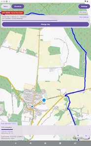
The core experience centers on an offline map that contains the whole West Highland Way route and a live GPS marker showing your current location relative to the path. As you walk the trail the app plots your progress, highlights the established route and keeps a running distance count for each day’s section. Rather than trying to replace guidebooks or booking services, the app concentrates on navigation accuracy, route visibility and an easy-to-use journal system that links notes and photos directly to map locations.
Controls and interface
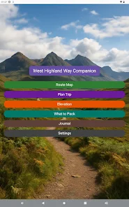
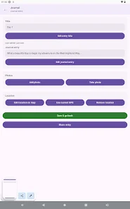
Interaction is intentionally simple to keep attention on the trail. Use familiar gestures such as pinch-to-zoom to inspect the map and tap to open details for the route or a journal entry. Long-pressing the map creates a memory pin where you can add a note and attach photos taken on the device. A compact toolbar provides quick access to the journal list, an overview of daily distances and settings for units and map styles. Visual markers and a clear current-location indicator reduce ambiguity on narrow or remote sections.
Progression and daily planning
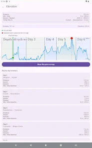
Progression is treated like a hiking plan rather than a game. The app organizes the West Highland Way into logical day stages that you can use as a template for your itinerary. For each stage you can track distance completed, time on the move and remaining distance to the next waypoint. This helps manage pacing, decide reasonable stopping points and preserve a day-by-day record of your journey. You can adjust the stage targets locally to match your fitness and weather considerations without relying on external services.
Visual style and level structure
The map styling is designed for outdoor readability: clear paths, contrasting terrain shading and discrete icons for key features such as towns, campsites and trailheads. The route is presented as a continuous line with implied sections that function like levels in a multi-day hike; each stage can be reviewed independently in the journal so you get a structured view of progress through the whole trail. The interface avoids clutter and emphasizes essential information—position, route and the next waypoint—so visual complexity does not distract while walking.
Customization and replay value
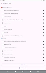
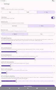
Customization options let you tailor the app to your preference: choose metric or imperial units, enable larger text for readability, change map contrast for different light conditions and set personal daily distance targets. The built-in journal and map pins create replay value beyond a single trip—reopen past hikes, review photos pinned to places you visited and export entries to keep a permanent record. The app becomes useful for pre-trip planning, training walks along sections of the route and for later reflection on the entire West Highland Way experience.
User experience and accessibility
Accessibility is considered in the UI design with legible fonts, high-contrast map themes and simple touch targets so it remains usable with gloves or in wet conditions. The journal supports short, structured entries so you can capture memories quickly. The app is optimized to minimize battery drain by allowing you to suspend map updates when desired and by relying on offline tiles rather than continuous data traffic, which is critical for long days in the Highlands.
Offline reliability and export
Offline play is central to the app: once the route and map tiles are downloaded, all navigation and journal features work without a network connection. GPS positioning runs locally on the device and displays your track even in signal-poor valleys. When connectivity is available you can export journal entries and photos using Android’s native share sheet to save copies or send them to email and cloud storage, preserving a permanent backup of the hike.
Challenges and limitations
The app deliberately avoids duplicating full travel planning tools: it does not provide live accommodation booking, public transport schedules or real-time weather forecasts. Its strength is focused navigation, progress tracking and memory-keeping specific to the West Highland Way. If you want a compact, offline-first companion to guide your daily stages and keep a lasting record of your walk, West Highland Way delivers those essentials while remaining lightweight and reliable for long-distance hikers.
- No virus
- No advertising
- User protection
Information
- File size: 30.00 M
- Language: English
- Latest Version: 1.2.1
- Requirements: Android
- Votes: 362
- Package ID: com.whw.companion
- Developer: West Highland Way
Screenshots


Explore More
Reach your fitness goals and maximize workouts with our revolutionary exercise apps. Track progress, log workouts, and analyze performance using our intuitive tracking tools. Follow customized training plans tailored to your level and interests. Learn new exercises and techniques with our video instructional library. Monitor heart rate, calories burned, and other metrics to optimize your routine.
View more