
Introduction
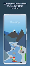
RiverApp - River levels is the ultimate app for all river enthusiasts, providing quick access to the latest water levels and river flows for rivers in the USA and 20 other countries worldwide. With data from over 40,000 hydrometric stations, the app is the most comprehensive app of its kind. Whether you're into kayaking, canoeing, fishing, or simply monitoring river conditions, RiverApp has you covered. Get real-time water levels, detailed maps, personalized alerts, and more. For whitewater sports enthusiasts, RiverApp offers additional features like navigability status, hazard information, and user-generated course additions. Download now and stay connected to your favorite rivers!
Features of RiverApp:
- Access to water levels and river flows: Get quick access to the latest water levels and river flows for rivers in the USA and 20 other countries around the world.
- Largest database of hydrometric stations: RiverApp - River levels contains data from the largest number of hydrometric stations in the world, with over 40,000 sites.
- Ideal for river-related activities: Whether you're into kayaking, canoeing, pack rafting, stand-up paddling, fly fishing, river surfing, hydroelectricity, or irrigation, RiverApp is the ideal application for all river-related sporting or professional activities.
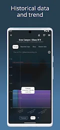
- Useful for monitoring river evolution: The app is also very useful for monitoring the evolution of rivers in the event of flooding, helping you stay informed and prepared.
- Free features: Enjoy free access to current water levels and flows in over 15,000 rivers in the US and around the world, water temperatures, detailed maps of hydrometric stations and whitewater sections, and configuration of personalized alerts for each station.
- Whitewater sports-specific features: For whitewater sports enthusiasts, RiverApp offers more than 4,000 referenced whitewater courses, display of navigability according to water level or flow, precise mapping of courses with quick access to put in and take out points, hazards display with photos, information on difficulty, length, and average gradient of whitewater sections, and the ability to add and modify whitewater courses by the user community.
Conclusion:
With its extensive database of hydrometric stations, it provides quick access to the latest water levels and flows for rivers worldwide. Whether you're a professional or a recreational enthusiast, RiverApp caters to all river-related activities, from kayaking to hydroelectricity. It also offers free features such as water temperature information and personalized alerts. For whitewater sports enthusiasts, the app goes above and beyond with its specific features, including detailed mapping, hazards display, and user-generated content. Download now to stay informed, plan your activities, and make the most of your river adventures.
- No virus
- No advertising
- User protection
Information
- File size: 33.91 M
- Language: English
- Latest Version: 5.10.2
- Requirements: Android
- Votes: 52
- Package ID: de.android.riverapp
- Developer: Florian Bessière
Screenshots


Explore More
Explore the world with confidence using our intuitive map software. Navigate unfamiliar cities, find hidden gems, and plan adventures with ease. Our powerful apps feature robust offline functionality, real-time traffic updates, and crowd-sourced points of interest. Customize maps to match your needs - save favorite locations, download areas for offline access, and share recommendations.
View more