Introduction
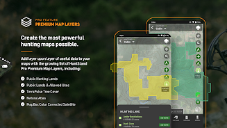
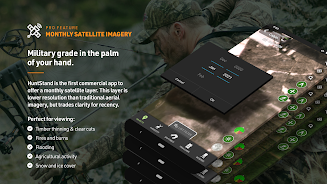
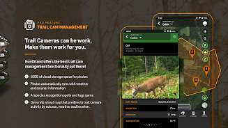
HuntStand: GPS & Hunting Maps is the ultimate app for hunters and land managers. Explore hunting terrains with detailed 3D maps, collaborate by sharing hunt areas, and access weather forecasts and game movement insights. View private and public property boundaries and utilize a nationwide rut map for hunting strategies. Enjoy free features like aerial imagery and trail camera management. Upgrade for advanced options including real-time satellite imagery and exclusive whitetail features. Elevate your hunting experience with the app, whether you're a hunter or land manager.
Features of HuntStand: GPS & Hunting Maps:
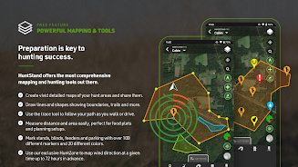
> Rich 3D Mapping: Plan your hunting areas with precision using dynamic 3D maps.
> Group Hunt Areas: Share hunt areas with hunting partners and family members for seamless collaboration.
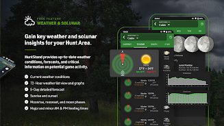
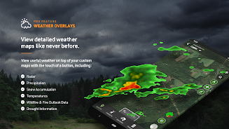
> Advanced Weather & Game Movement Forecasts: Stay informed with a 7-day whitetail activity forecast to know the best times to hunt.
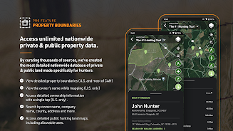
> Extensive Property Line Insights: Access detailed private and public property boundaries, as well as public hunting land maps.
> Nationwide Rut Map: Visualize comprehensive rut data on a color-coded map to optimize your hunting strategies.
> High-Resolution Aerial Imagery: Create detailed maps of your hunting areas with high-quality satellite imagery.
Conclusion:
HuntStand: GPS & Hunting Maps is North America's premier hunting and land management app. Access 3D mapping, collaborative hunt areas, detailed weather forecasts, property boundaries, nationwide rut maps, and high-resolution aerial imagery. Upgrade to the app for additional features. Try it for free and enhance your hunting experience today!
- No virus
- No advertising
- User protection
Information
- File size: 37.48 M
- Language: English
- Latest Version: 7.6.3
- Requirements: Android
- Votes: 100
- Package ID: com.huntstand.core
Screenshots
Explore More
Be prepared and plan your days better with our new weather app. Get real-time hyperlocal forecasts, customizable alerts and widgets, and detailed hourly projections. Beautiful photo backgrounds change dynamically based on conditions. Intuitive radar and satellite imagery help you visualize storms and patterns. Get humidity, precipitation probability, pollen count, and other useful data at a glance. Save favorite locations like home, work, or travel destinations for quick access.

RailTrip (PasseGares)

Launcher OS Pro

Crossbar

Launcher OS™

Air Navigation Pro

New Orleans News from WWL

WHIO Weather

Live Weather Radar Launcher
You May Also Like
Comment
-
Great app. I'm still learning how to use it but so far it's been easy to use and functional. Definitely would recommend2024-06-29 02:06:00
-
Incredibly useful for hunting or even just exploring the outdoors. I used it all last year scouting and hunting for mule deer as well as hiking with my daughter. The property lines and public land filters saved me many hours trying to find legal areas to hunt in an area surrounded by ranches and other private property. The only thing I'm not crazy about is the crosshair UI for drawing lines and boundary shapes. Free drawing with a stylus would be a nice improvement.2024-06-28 16:07:44
-
I would recommend it for android users bc it worked flawlessly for me. But on my iPhone I’ve downloaded multiple versions on multiple iPhones and not one of them worked good enough to use. The gps was all over the place most times the map wouldn’t even load and anything I tried to save waypoints or anything the app would crash. I’ve since paid for onX maps and it’s the best app for hunting and the price is reasonable in comparison to some of the other similar apps2024-06-27 18:53:19
-
Valuable resource for my small hunting parcel. Easy to use and a great tool to have while out on your land. Keep track where all your stands, cameras and future stand placements are at all times. I love the face that you can see where the property lines are at and who owns them for great. All in all excellent app. All it really needs is hunting conditions and predictions to be a all inclusive app.2024-06-27 07:23:08
-
I love the app. I purchased the pro upgrade, but after a couple weeks when I had to replace my phone, the pro plan disappeared from my app. I still have my receipt on my bank statement showing the purchase, but I don't get any benefits anymore. I've sent a couple emails and haven't heard anything back. I need to be able to use the app to its fullest as an outfitter so the sooner someone can contact me that would be great. (update: it's been over a week and still nothing)2024-06-26 19:30:27
-
Great app. Just wish it had an updated map. My ground on this map looks nothing like it does now or has for the past 3-4 years. Other than that i love this app and use it frequently. (UPDATE) just spent 25 bucks on the pro version thinking it would show me more recent pics of my ground. Instead it has old pictures of the ground before they were even put back in trees. Cant believe I just wasted my money on older pictures.2024-06-26 07:38:27


