Introduction
Ultimate GPS Camera Pro is a professional GPS map camera that embeds accurate location data, timestamps and map overlays directly onto your photos so you can document site conditions faster and with confidence. Built for real estate agents, construction managers, architects, surveyors and field engineers, the app captures latitude, longitude, altitude and compass headings on every image and produces ready-to-share PDF reports. With 10+ customizable geo-card templates, folder-style project organization, image markups and cloud backup options, Ultimate GPS Camera Pro removes manual editing and streamlines field reporting across projects and clients.
Key Features
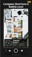
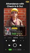
⭐ Advanced geotagging: automatic Latitude, Longitude, Altitude and compass heading stamped on every photo.
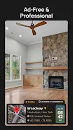
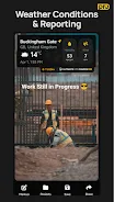
⭐ Custom Geo-Card Templates: choose from 10+ professional templates including weather, map and address fields — ad-free.
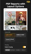
⭐ One-tap PDF reports: compile project images into detailed, shareable PDF documents with a single action.
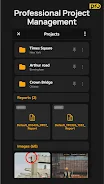
⭐ Folder-wise project management: organize photos file-manager style by site, client or job for quick retrieval.
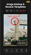
⭐ Image markups: add notes and drawings directly on GPS-tagged photos to highlight site details or defects.
⭐ Cloud backup and multiple map styles: secure your images to cloud storage and switch between satellite, terrain or hybrid maps.
Advantages
✅ Speeds field reporting by embedding location and timestamp data at capture, reducing post-processing work.
✅ Keeps project photos organized and easy to retrieve with dedicated folders for sites, clients and jobs.
✅ Professional output without extra tools: create comprehensive PDF reports from documented images.
✅ Ultimate GPS Camera Pro is tailored to construction, real estate and engineering workflows, improving on-site documentation efficiency.
Disadvantages
❎ Accuracy depends on the device GPS and signal conditions, so results can vary by hardware and environment.
❎ Not a substitute for survey-grade instruments when certified, survey-level measurements are required.
- No virus
- No advertising
- User protection
Information
- File size: 113.59 M
- Language: English
- Latest Version: 1.8.1
- Requirements: Android
- Votes: 356
- Package ID: com.ultimategpscamera.pro
- Developer: Pravin Gasva
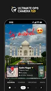
Screenshots


Explore More
Be prepared and plan your days better with our new weather app. Get real-time hyperlocal forecasts, customizable alerts and widgets, and detailed hourly projections. Beautiful photo backgrounds change dynamically based on conditions. Intuitive radar and satellite imagery help you visualize storms and patterns. Get humidity, precipitation probability, pollen count, and other useful data at a glance. Save favorite locations like home, work, or travel destinations for quick access.

skateable

WITAL

Nature Path Guide

Park Ranger

Not a Clock: Aesthetic Widgets

Melvine

Glassify - Widgets & Themes

Active Husky