

Introduction
QRSgps is a compact GPS utility that combines precise location tracking with offline waypoint management, route planning and quick coordinate sharing. Designed for professionals and casual users, QRSgps simplifies navigation tasks with an intuitive interface and tools for exporting data, saving favorite spots, and creating accurate tracks.
What the app does
At its core QRSgps turns a smartphone into a reliable navigation instrument. It records real-time tracks, logs timestamps and altitude data, and displays current coordinates in multiple formats. If you work in field surveying, outdoor recreation or delivery logistics, the app adapts to different needs and keeps essential location information easy to access.
Key capabilities
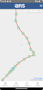
- Live tracking - continuous breadcrumb trails recorded with adjustable sampling intervals.
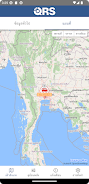
- Offline maps - cache map tiles to maintain navigation when cellular service is unavailable.
- Waypoint management - add, edit and categorize points of interest with custom labels.
- Data export - save routes and waypoints in common formats such as GPX or CSV.
- Coordinate tools - switch between decimal degrees, DMS and UTM with a single tap.
How it works in practical terms
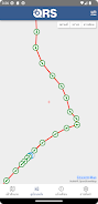
QRSgps focuses on straightforward workflows. Start a recording session, let the app log your path, and stop when you finish. Saved tracks appear in a chronological list where you can rename entries, attach notes, or trim unwanted segments. Routes can be reopened on the map for review, shared via email or uploaded to cloud storage for collaborative projects.
Interface and performance
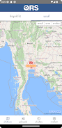
The design emphasizes clarity: large coordinate readouts, simple action buttons and an uncluttered map view. Map rendering is responsive even on older devices, and battery impact is minimized by configurable accuracy and sampling options. Developers included a dark theme to reduce glare during low-light use, and the layout scales well across phones and tablets.
Customizing the app for your workflow
Customization helps QRSgps serve multiple professions. You can create categories for different site types, assign color codes for quick visual sorting, and set default export formats to match downstream tools. For team operations, shared naming conventions and export templates reduce friction when multiple users exchange data.
Tips for new users
- Calibrate your device compass before relying on heading information for precise direction finding.
- Lower GPS sampling frequency when conserving battery; increase it when high-resolution tracks are required.
- Use offline map packs prior to entering areas with poor coverage to ensure uninterrupted navigation.
- Regularly export and back up critical tracks to avoid accidental data loss.
The app offers simple gesture controls to drop a waypoint quickly and an undo option for accidental marks. Beginners can benefit from testing the app on a short local route to become familiar with recording and exporting functions without pressure.
Safety and data handling
QRSgps stores location data locally and provides export tools so users retain full control of their information. For sensitive projects, you can disable automatic uploads and rely on encrypted cloud services of your choice. The app avoids unnecessary permissions, requesting only what is essential to record and share geospatial information.
Getting started
Installing the app is straightforward. Grant location permission when prompted, set preferred units and sampling rate, and run a quick calibration. Creating a first waypoint and recording a short track takes less than a minute, giving a hands-on feel for how QRSgps fits into your routine. Regular updates add map improvements and reliability patches, so keep the app current to benefit from ongoing refinements.
For anyone who needs dependable positioning, sensible export options and flexible display choices, QRSgps delivers a practical balance between power and ease of use. Explore settings to tailor performance, and lean on the waypoint and export features to integrate recorded data into your broader workflows.
- No virus
- No advertising
- User protection
Information
- File size: 12.82 M
- Language: English
- Latest Version: 2.0.1
- Requirements: Android
- Votes: 388
- Package ID: th.co.qrsgps.app
- Developer: บริษัท ดาต้าแล็บ โซลูชั่น จำกัด
Screenshots






















Explore More
Equip yourself with our all-in-one toolbox app for everyday tasks and projects. Instantly convert between units, calculate tips, scan documents, manage files, and more with handy productivity tools. Includes a level, compass, QR code reader, ruler, speedometer, decibel meter, and flashlight. Save frequently used tools to your customizable dashboard for one-tap access. Track billable hours, wages, budgets, and invoices. Annotate screenshots, magnify labels, and sign PDFs on the go.

Heart Face Camera - Snap Cat Selfie Cam

Weather !

Arranger Keyboard

掌上KD
FitAI+ : Water, Diet, Measure

Reindustrialize LLC

Athol CU Mobile Banking

Seth Rollins Wallpaper 4K