

Introduction
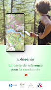
Iphigénie is a powerful offline mapping and navigation app designed for outdoor enthusiasts and professionals who need detailed topographic maps, reliable route planning and GPS tracking. The app emphasizes precision, custom layers and offline use, offering tools for hiking, cycling, surveying and fieldwork.
Key Features at a Glance
Iphigénie combines high-resolution topographic maps with robust routing tools and a focus on offline availability. Users can download map tiles for entire regions, trace routes with waypoint editing, and record tracks with live statistics. The app supports multiple map sources, adjustable overlays, and export options in common formats.
Maps and Data Sources
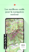
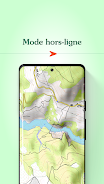
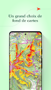
One of the strengths of Iphigénie is its support for a wide range of map providers and layers. You can switch between topography, satellite imagery and specialized thematic layers. Maps are cacheable for offline use, and the detail level stays consistent even when zoomed in, which makes the application suitable for remote trips where cellular service is limited.
Route Planning and Navigation
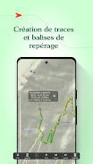
Route creation is flexible: lay down waypoints manually, snap to trails, or import GPX files. The built-in route planner calculates distances, estimated time and elevation profiles so you can evaluate difficulty before you set out. During navigation, turn-by-turn prompts, compass alignment and an adjustable GPS update rate keep you on track with minimal distraction.
Tools for Fieldwork and Outdoor Use
Iphigénie includes tools tailored to professionals and hobbyists alike. Use the track recorder to monitor speed, ascent and cadence; attach photos or notes to waypoints; and measure precise distances with on-screen tools. Data can be exported in GPX or KML for further analysis or archived for reporting.
Interface and Customization
The user interface balances depth and accessibility. Main controls are reachable from the map screen, while advanced settings are grouped into clear menus. Customize the map display with optional overlays, adjust the color and thickness of tracks, and define which statistics appear during recording. Themes and layout choices help reduce visual clutter in bright outdoor conditions.
Performance and Compatibility
Performance is optimized for mobile devices: map rendering is responsive, caching reduces data usage, and background GPS tracking is designed to minimize battery drain. Iphigénie runs smoothly on current Android versions and offers sensible defaults for older hardware. Regular updates maintain compatibility with new map sources and add performance improvements.
Offline Workflow and Data Management
Downloaded map packs provide a reliable offline workflow. Iphigénie lets you manage stored maps, remove outdated tiles, and prioritize space by region. Syncing between devices is possible through exported files, and cloud backup options are available for preserving track history and custom layers.
Safety and Practical Features
Practical navigation aids include a configurable alert system for deviations from planned routes, automatic waypoint snapping to nearby trails, and an emergency coordinate display for quick sharing. The app also supports geotagged photo capture so that observations are tied directly to location data.
How to Get Started
Begin by downloading the app and choosing the map regions you need. Familiarize yourself with track recording and practice creating simple routes. Explore import/export functions to connect Iphigénie with your preferred planning tools, and tweak display settings for optimal readability during your first outing.
Who Benefits Most
Iphigénie is well suited to hikers, mountain bikers, surveyors and outdoor professionals who require accurate mapping and reliable offline navigation. Its balance of advanced features and accessible controls makes it a practical choice for anyone who spends time off-grid and needs a dependable mapping solution.
Final Notes on Usage
For the best experience, keep your map packs updated, review battery-saving settings before long excursions, and regularly export important tracks for backup. With careful setup, Iphigénie becomes a versatile companion for planning, navigating and recording outdoor adventures or field operations.
- No virus
- No advertising
- User protection
Information
- File size: 22.83 M
- Language: English
- Latest Version: 11.1.7
- Requirements: Android
- Votes: 424
- Package ID: com.iphigenie
- Developer: Iphigénie
Screenshots
















Explore More
Equip yourself with our all-in-one toolbox app for everyday tasks and projects. Instantly convert between units, calculate tips, scan documents, manage files, and more with handy productivity tools. Includes a level, compass, QR code reader, ruler, speedometer, decibel meter, and flashlight. Save frequently used tools to your customizable dashboard for one-tap access. Track billable hours, wages, budgets, and invoices. Annotate screenshots, magnify labels, and sign PDFs on the go.

Cartola

HFonts - font & emoji manager

Virink
RegenRadar

Chatbot - AI Image Generator

Skyworker

ho.

HUAWEI 360 Camera